Stratigrafia dei PozziWell Stratigraphy
The detailed analysis of both cuttings and core, sampled during drilling, enables reconstructing the stratigraphy of the site. The PITOP2 well has the greatest and most complete data of the site, acquired during 121/4” and 81/2” phases (from 42 to 282 m and from 282 to 385.5 m, respectively). During the drilling of the PITOP2 well, Baker Hughes Inteq, a mudlogging company, sampled cuttings from depths ranging from 44 to 385.5 m, which provided a detailed lithological description (masterlog). Gravels and lightly cemented conglomerates with limestone and dolomitic clasts are alternated to soft and plastic brown ocher clay until the first 180 m. The same lithologies, but with a greater cementation of the conglomerates and different coloured (beige-brown-grey) clay that is silty at times, are found up to the bottom of the well. Furthermore, Schlumberger Limited acquired several electric logs in the PITOP2 well after both phases (121/4” and 81/2”) and in the PITOP3 well only after the 81/2” phase. The recorded well logs are listed in the Table below.
| Well | Run | Logs | Interval (m) |
|---|---|---|---|
| PITOP2 | 1 | DSI – GR - EMS | 246.0 - 41.5 |
| PITOP2 | 2 | DSI – GR - EMS | 387.5 - 250.0 |
| PITOP2 | 3 | USIT - CBL | 250.0 - 41.0 |
| PITOP2 | 4 | Gyro survey | 387.5 - 0.0 |
| PITOP3 | 1 | DSI – GR - EMS | 426.0 - 97.6 |
| PITOP3 | 2 | DSI – GR - EMS | 333.0 - 253.7 |
The analysis of data from the master log and electric logs, combined with the 1:150,000 geological map (Carulli, 2006), reveals the presence of Quaternary alluvial sediments (gravels and clays) and the Upper Miocene Montello conglomerate. The Montello conglomerate, approximately 900 meters thick, consists mainly of polygenic and heterometric conglomerates with carbonate clasts, as well as subordinate siltstones and sandstones. Initially marine, it later evolved into a continental environment (Carulli, 2006). At the PITOP site, only the upper member of the Montello conglomerate is present, forming several-meter-thick layers. This unit is characterized by limestone and dolomitic clasts interspersed with beige, brown, and grey silty clays. The clasts range from sub-rounded to sub-angular, varying in size from centimeters to decimeters, and are sometimes well cemented with calcareous cement. The interface between Quaternary sediments and Neogene formations is not clearly defined in Piana di Toppo, due to the absence of biostratigraphic analysis. The figure below illustrates the stratigraphic correlation between the three wells: PITOP1 (P1), PITOP2 (P2), and PITOP3 (P3). Where Orange represents clay and Grey represents conglomerate. The top view on the left side of the figure, shows the distances between the wells, projected onto an arbitrary line parallel to the P1–P3 segment.
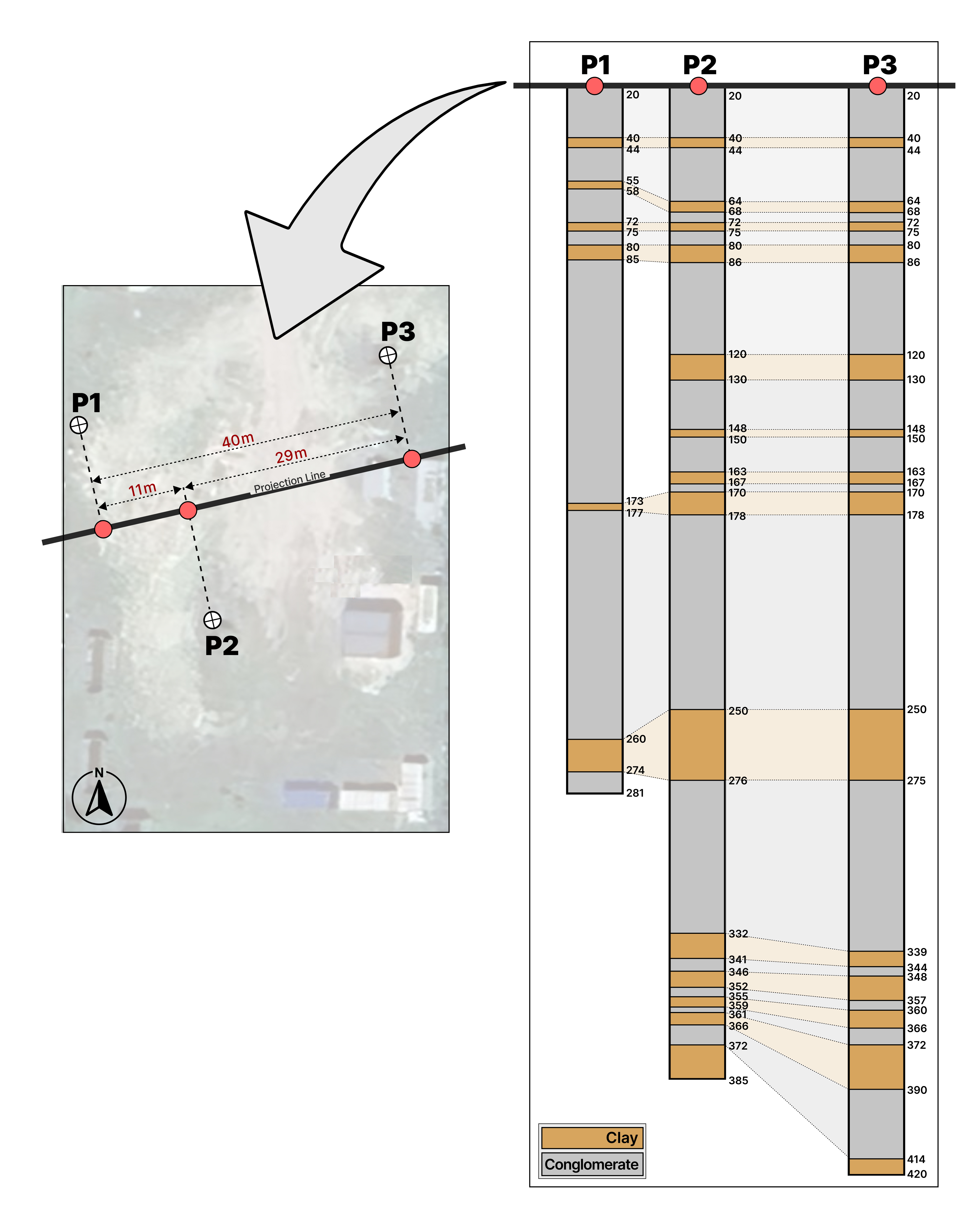
The geological layers at the PITOP site are primarily sub-horizontal, but from 275 meters to the bottom of the wells, they show a slight inclination, as interpreted from the PITOP2 and PITOP3 electric logs. The variable thickness of the conglomerate layers indicates a continental depositional environment, shaped by terrigenous sedimentation within an alluvial fan or plain. This process is closely linked to the activity of the Meduna and Cellina Streams.